Site 2: Early Explorers
PREV NEXT
After Captain James Cook “named” Cape Byron(Walgun) on 15 May 1770 many other ships passed by before any white people landed in the area, including Matthew Flinders in 1802 in Investigator and Captain John Oxley in Mermaid in 1823 on his survey of the NSW coast and Moreton Bay.
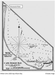
It was Captain Henry Rous, and William Johns in 1828, in the Rainbow who made the first documented landing. Rous and his crew collected depth soundings of the bay. Johns prepared a map of the coast and bay between Cape Byron and “a small river to the north”, Brunswick River. That map shows a salt water lagoon (Belongil Creek), Julian Rocks(Nguthungulli) and good anchorage at what is now Clarkes Beach just west of “The Pass”(Currenba). They identified the bay as providing safe anchorage for both large and small vessels.
Surveyor Robert Dixon’s visit to Cape Byron in June 1840 is the first documented white person visit by land. He recorded a tribe of fine-looking, Aboriginal men fishing with nets and established a trig station on Cape Byron as a base for future surveying.
With the passing of the Crown Lands Alienation Act in 1861 the land in the Byron(Cavanbah) area was open for free selection by settlers. However, a reserve around Cape Byron extending from Tallow Creek to Belongil Creek precluded selection along this part of the coast. Part of that reserve survives today as the Cape Byron Reserve.
There were still no signs of white habitation at or near Cape Byron in 1865 when the NSW Inspector of Police visited. Rugged terrain, deep rivers and dense vegetation prevented easy access by land from any direction. It is recorded that the cedar-getters were at Byron Bay by 1869 and by the early 1870’s had set up tent camps at Byron Bay.
The earliest dwelling recorded within the present Byron Bay area was a lonely slab hut in Palm Valley first noted in 1882. This was an illegal occupation.