Byron Bay Grows
POPULATION GROWTH AND CHANGES IN BYRON BAY
The town of Byron Bay had very humble beginnings. It was not until 28 August 1896 that it was officially declared a town even though the first allotments were offered for sale in July 1886. While many of those blocks were purchased very few homes were built until completion of the railway in 1894 and the town became viable.
With the influx of farmers, settlers and merchants following the development of the port and first jetty in 1888 and the opening of the railway and the NORCO butter factory in the 1890’s, the town’s population grew rapidly and roughly.
The Byron Shire local government area incorporating 567 square kilometres was formed in March 1906. However, the town of Mullumbimby separated from the Shire on 1 July 1908 and remained “outside” the shire until 1 October 1980 when the two were amalgamated.
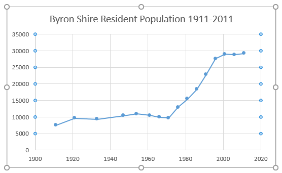
It is not until the first 1911 Australian census that reliable population numbers become available. It records 7,504 people living in Byron Shire plus the Municipality of Mullumbimby. The exact number for Byron Bay town are difficult to extract. Those living in the town were mostly living in the core of the town laid out by Government Surveyor Poate in 1884. In the 50 years from 1921 to 1971 the population of the Shire remained remarkably stable ebbing to a low of 9,329 in the 1933 census and peaking at 10,921 in the 1954 census. These were the “steady years” with any change in the Shire’s population largely reflecting changes in the population of Byron Bay town which in turn reflected the demand for workers in an industrial town.
The years of 1947 to 1966 marked the peak of Byron Bay’s industrial era. Soldiers had returned from WWII, immigrants arrived from Europe arrived and the “baby boomer” generation was born. The town was unkindly described as “reeking from the stench originating from the piggery, meatworks and whaling factories with their effluent colouring the sea and washing on the shore”.
Local industries increased production and support businesses expanded. More employees required more services providers such as teachers, shop-keepers, bankers, health workers, council workers and police. All needed places to live. By the early to mid-1960’s few vacant building blocks remained in the core of the town. New subdivisions were planned and developed to accommodate the demand for new dwellings from locals.
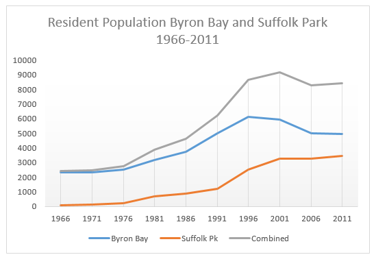
Wategos was the initial area to be developed with the first blocks released in 1961. The Industrial and Arts Estate of 50 acres was opened for development in 1972 and the nearby Sunrise Beach residential development opened soon after. The “Sandhills” subdivision was developed on the area behind Main Beach between Middleton and Massinger Streets and back as far as Marvel Street after sand mining had been completed there. The land had been converted from swamp and dunes into a topography suitable for development. The first Sandhill Estate blocks were sold in early 1974. The first land release in the Pacific Vista Estate was made in 1980. Suffolk Park commenced its development boom in the mid 1970’s with the number of residents jumping 184% in the five years from 1976.
But “clearer air” and these new developments also attracted new people to the town and Shire. This new “wave” started arriving in the second half of the 1970’s soon after the closure of NORCO butter and bacon factories, the cessation of sand mining and processing and the reduction of processing from the meatworks. The two decades 1976 to 1996 were the “great growth” years. The number of residents in the Shire jumped 14,643 or 113% while the population of the expanded Byron Bay town catapulted 213%; from 2,764 to 8,658.
In those twenty years the demographics of the Byron Bay underwent fundamental change. Industrial workers were replaced by those in the service industries, particularly tourism, and those who sought beach or bush lifestyles. Most of the remaining locals, and the newly-arrived surfers, hippies, environmentalists and those looking for a peaceful and beautiful place to live all valued the intrinsic natural assets and beauty of the area. They understood that the town and its hinterland needed assistance and time to recover. Any proposed development that would significantly impact the environment, compromise the natural beauty of the area or compromise their selected lifestyles was unwelcome. Community resistance mounted to further development but strong support was available for initiatives that protected and enhanced the natural environment and attractions.
By the mid 1990’s the new “ethos” of Byron Bay was fully formed. A triangular tension developed between a tourism based economy, protection of the environment and natural beauty and the expectation of the “life-stylers” that they should be able to live their lifestyle of choice. That tension ebbed and flowed through the town and Shire with the resident population numbers of both changing only slightly since 1996.
The Australian census numbers from 2001 to 2011 for the resident population of the Byron Bay (including Wategos, Pacific Vista and Sunrise Beach), Suffolk Park and for the Byron Shire for the same period are shown in Table 1 below.
Table 1: Resident Population of Byron Bay, Suffolk Park and Byron Shire 2001-2011 Census*
| Year | Byron Bay town | Suffolk Park | Byron + Suffolk | Byron Shire |
| 2011 | 4,959 | 3,467 | 8,426 | 29,209 |
| 2006 | 4,981 | 3,291 | 8,272 | 28,766 |
| 2001 | 4,900 | 3,265 | 8,165 | 28,916 |
*Excludes visitors present on census night. (Source – Australian Bureau of Statistics)
There was a modest increase of residents in Byron Shire of just (1.0%) from 2001 but little of that increase occurred in Byron Bay town. Suffolk Park increased by 202 or 6% in that time.
The change in the number of dwellings in Byron Bay, Suffolk Park and Byron Shire reported in the censuses since 2001 are shown in Table 2.
Table 2: Dwellings in Byron Bay, Suffolk Park and Byron Shire 2001 – 2011 Census*
| Year | Byron Bay | Suffolk Park | Byron + Suffolk | Byron Shire |
| 2011 | 3,092 | 1,602 | 4,694 | 14,455 |
| 2006 | 2,858 | 1,485 | 4,343 | 13,564 |
| 2001 | 2,911 | 1,428 | 4,339 | 13,095 |
*Includes unoccupied dwellings (Source – Australian Bureau of Statistics)
(Source – Australia Bureau of Statistics)
(Source – Australia Bureau of Statistics)
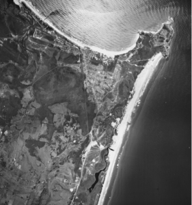
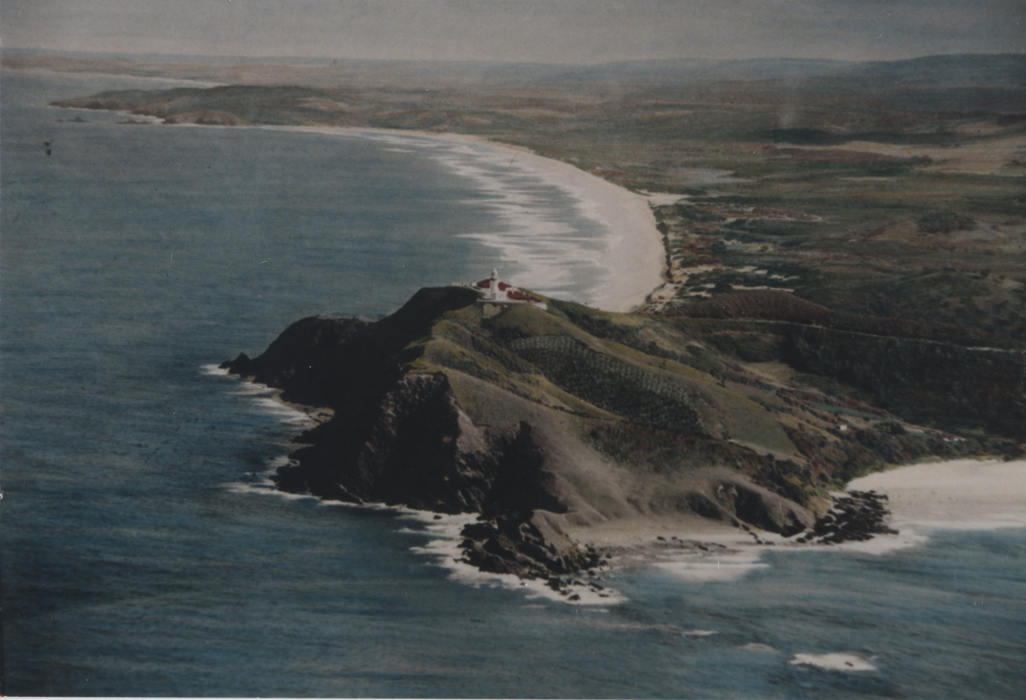
1966 air photo of Byron Bay. (Source – NSW Govt Image)
It shows Byron Bay at the peak of its industrial development, just as Wategos is being opened but before the Arts and Industrial, Sunrise Beach, Sandhills and Pacific Vista Estates and Suffolk Park are developed. Look closely at the image and you will notice a “slick” of meatworks waste extending eastwards from the new jetty to Cape Byron. Sand mining has yet to commence behind Main Beach but dredges are active at Cosy Corner and what becomes Red Devils sports field and the High School. Previously mined areas are the white patches inland from the beaches. Tallow Creek retains its original form. The mineral sand processing plant can be seen on the site that becomes Woolworths. NORCO’s butter factory appears at the southern end of Jonson Street. NORCO’s piggery, is now the Arts factory,
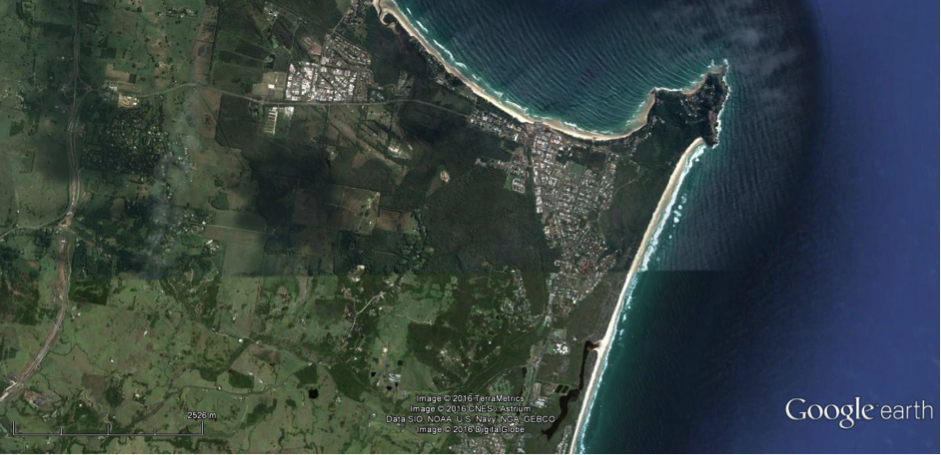
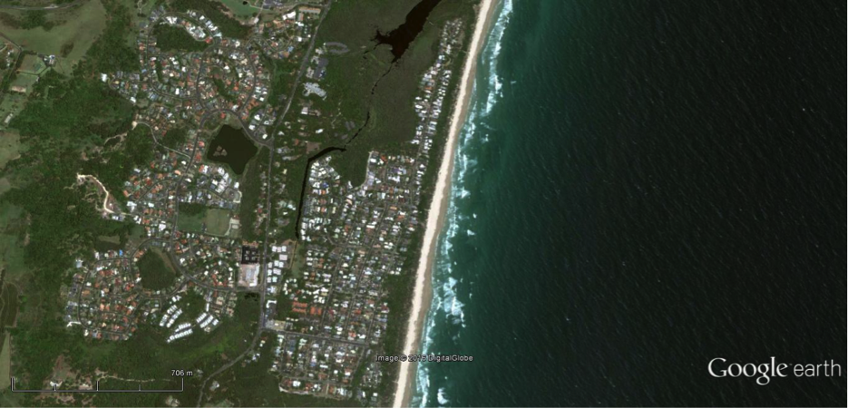
2016 Image of Byron Bay shows Wategos, Pacific Vista, Sandhills Estates, the Industrial Precinct and Sunrise Beach plus part of Suffolk Park all of which have been developed in the 50 years since the 1966 image above. Although Tallow Creek has been straightened by the sand mining much of the industrial footprint has been removed or repaired and is no longer visible. Vegetation has recovered and National Parks and Reserves protect significant areas previously impacted. (Source – Google Image)
WATEGOS BEACH
Wategos Beach known locally as Wategos, but originally called Little Beach, was incorporated in a Reserve in the 1861 classification of land at Cape Byron and therefore unavailable for settlement. However, after a change in classification in 1933 three six-seven acre blocks (129, 130 and 131) on the beach were gazetted and leased for ten years to private individuals. Murray Watego, born in September 1895 a son of a native of the Loyalty Islands and an English mother, and a WWI veteran and casualty leased block 131. Cyril Halpin leased block 129 and Bernard Higgins leased block 130. In 1936 Murray Watego was also granted a Permissive Occupancy lease over a larger area on the Cape abutting the lighthouse reserve and the other leases. He, his wife and their ten children cleared the land and grew bananas and vegetables for sale locally and for export. With time the beach and the area behind it became known as Wategos. Murray Watego died in July 1953. His family continued to live on the lease until the end of 1959. Their leases and the other two leases then owned by a Mr Blackmore expired in 1960.
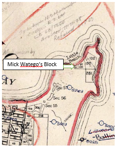
(Source NSW Govt Map)
Bananas on slopes and vegetables near house at Wategos Beach. (Source – EJW – RTRL)
In 1961 the government surveyed and gazetted a 25 acre residential development at Wategos Beach which included the areas previously leased by the Watego family and Mr Blackmore. Approximately 86 blocks were available for auction on 25 November 1961 at an average cost of about $700 each (or about six month’s average wage at that time). However, for many blocks no bids were received. A further six auctions were required (July 1964, June, 1968, January 1970, January 1971, September 1972 and May 1973) before all of the blocks were sold. The prices realised in the later auctions were significantly higher than at the earlier ones. Seventeen blocks realised an average $2,320 each in January 1970, well above the reserve of $730 each. This trend continued with non-locals buying most blocks from 1970 and pushing prices up.

Layout of Wategos subdivision 1962. Names of bidders added. (Source – NSW Govt Map)
It took more than 25 years after the initial 1961 auction at Wategos before most of the blocks were built on.
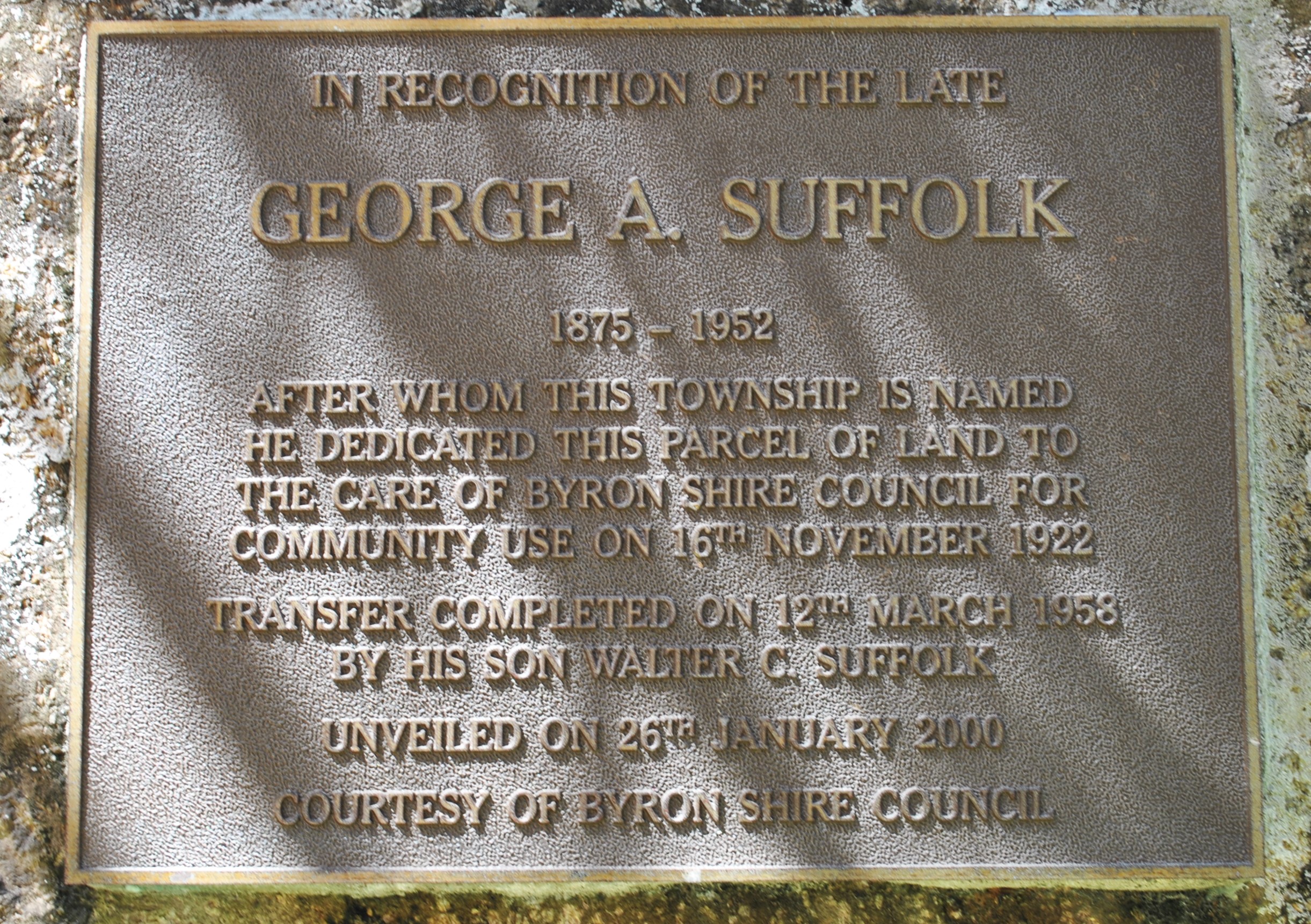
SUFFOLK PARK
Adjacent to Byron Bay town on its southern side is Suffolk Park. It was originally part of land owned by George Suffolk (1876 – 1952). In 1922 the Suffolk Park Estate subdivision was laid out on this land and offered for purchase as beach side estate. A block of this land was gifted to the Shire Council and reserved for public use. The Suffolk Park Caravan Park occupies that piece of land. However the subdivision was unsuccessful. Even in 1936 it was still without services. The streets were named after local Byron Bay identities. The subdivision remained essentially undeveloped and uninhabited until the late 1950’s with only a modest number of dwellings erected. A NSW Government image of 1958 shows the gravel streets laid out with dwellings on a few of the blocks.
(Source – John Main)
Suffolk Park was gazetted as a place in 1970 just as the demand for beachside property surged in this part of Australia and homes began to be erected on those lots laid out 50 years earlier. By 1976 the census records 239 residents living in Suffolk Park. This increased to 1221 in 1991, reflecting the fact that it was becoming a “dormitory suburb” for people working in Byron Bay or perhaps it followed establishment of the local Park Hotel in 1989. In the early 1990’s Suffolk Park began to spread west well beyond the original subdivision of 1922, across Broken Head Road into areas now called Byron Hills and Baywood Chase. The 2011 census records 3468 people living in 1602 dwellings in Suffolk Park; a 1350% increase in 35 years since 1976.
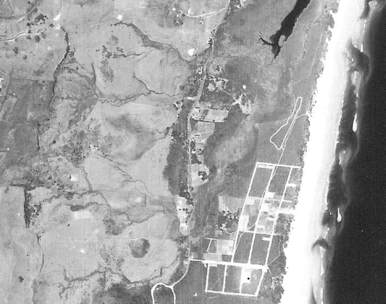
Suffolk Park layout and development in 1958. (Source – NSW Govt Image)
Suffolk Park in 2014 (Source – Google Image) 2014